
The Great Flood and the Green Sahara
Civilization before Egypt and Sumer.

20,000 years ago, during the Last Glacial Maximum (LGM), global sea levels were much lower than at present day. This created a land bridge between Russia and Alaska and between Britain and France.

Earth exited this ice age and began to warm, leading to an event known as Meltwater pulse 1A. MP1A was a period of rapid sea level rise over roughly 800 years. For comparison, current sea level rise has been estimated at 3mm per year. During MP1A, sea level rise was between 40mm to 60mm per year. At the end of MP1A, sea levels had risen between 30 to 50 meters.
MP1A occurred around 12.7k BC to 11.5k BC. After MP1A completed, global sea level rise continued. Similar to genetic evolution, sea level rise is not best modeled as "uniform, gradual change" but rather as "punctuated equilibrium," where sudden changes occur, slow down, and are followed by new sudden changes. MP1A was followed by MP1B, which occurred between 9.5k BC to 9.2k BC. The last meltwater pulse in this series, MP1C, occurred between 6.2k BC and 5.6kBC.
The effect of sea level rise was the submerging of lost continents around the world. In the Caribbean, the Great Bahama Bank was once dry land, and the sunken territory was similar in size to the modern day island of Cuba. Massive amounts of land on the North American Atlantic coast were submerged, stretching from the coast of Canada down to the southern tip of Argentina.
In the Pacific region, similarly dramatic flooding destroyed the previously exposed continents of Sundaland and Sahul, the remains of which are the Malay Archipelago, New Guinea, and Australia. Japan was also connected to China by a massive coastal land bridge.
Finally, an important area which is presently submerged but which was once dry land was the Persian Gulf. The flooding of the Persian Gulf is important for several reasons:
This area is adjacent to the fertile crescent, which is known for early farming activity.
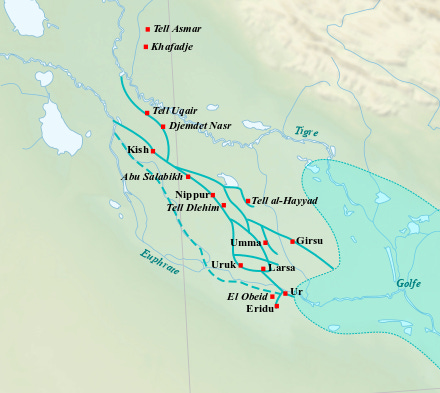
This area is adjacent to the most ancient civilization of Sumer.
If the area contained human settlements, and was flooded, this would have resulted in a migration of refugees out of the Persian valley into neighboring territories.
The earliest evidence of agriculture is typically dated to around 10k BC. However, if agriculture existed in a Persian Valley, which was subsequently flooded, this could open up the possibility of pre-Natufian agriculture existing in flooded regions. The flooding would obscure evidence.

Today, Saudi Arabia is thought of as one of the driest and least hospitable places in Eurasia. However, there is some evidence that Saudi Arabia experienced higher levels of rainfall as recently as 4k BC.1 These high levels of rainfall allowed for the existence of “paleolakes.” “Paleolake” is a term which refers to an ancient basin which was once filled with fresh water, but is now dry. In its present dry state, paleolakes are referred to as Playas, which is Spanish for beach.
One such site of a Saudi paleolake is at Jubbah:
“Radiocarbon dating of the main palaeolake at Jubbah [..] yielded a date of [4,685 BC]. [..] This fits well with other palaeoenvironmental evidence in the region for the early Holocene being more humid than its present day arid environment: a perennial lake existed 240km west of Jubbah at Tayma oasis [during 8k BC to 7k BC] [..] An early Holocene humid phase [from 7250 BC to 5250 BC] is reported in cores taken from the Red Sea [..] and speleothem records at Soreq Cave in the southern Levant show an overall trend of increased precipitation from the onset of the Holocene [12k BC] to [5.5k BC], with peaks at [6500 BC] and [5500 BC].”2

The term Wadi, much like the term Playa, refers to a temporary river or dried up river bed or river valley. The Wadis of Saudi Arabia do fill up during periods of unusual rainfall, but do not form permanent rivers. However, during the early Holocene (10k BC to 4k BC), it is likely that higher levels of rainfall, which created permanent paleolakes, also increased water volumes in Saudi Arabian Wadis. It is difficult to determine the extent of this volume, and whether it allowed for the maintenance of permanent river systems. In the optimal scenario, Saudi Arabian river systems could have exceeded the volume of the present-day Tigris, Euphrates, or even the Nile.
Wadi al-Batin is 45 miles, Wadi Hanifa is 75 miles, and Wadi al-Rummah is 370 miles. However, these numbers are deceptively small. In the Grand Canyon and other American river canyons of the south west, there are no sand dunes. River beds can dry up, but without sand to cover them, they are still visible. By contrast, much of the original length of the Saudi Arabian Wadis has been eroded, covered up, or filled in by shifting sand dunes.
However, while Saudi Arabia may have had a more extensive permanent or semi-permanent river system than today, greater middle eastern rainfall would also affect neighboring climate systems in Egypt and Mesopotamia.
The Arabian Humid Period is well attested in paleoclimatology.3 It was the neighbor of an African Humid Period (also confusingly known as AHP). “The most recent AHP, during the early Holocene, spans from [9.7k BC to 3k BC].4 This African Humid Period coincides with the origins of agriculture, as well as the rise of ancient Egypt.
While the African Humid Period is often imagined to have affected the entirety of the Sahara uniformly, there is some evidence to suggest that the northern coast of Africa was less affected than the rest of the Saharan region. Specifically, “North of 28°N, the data do not support lower dust fluxes during the AHP.”5 This would mean that the Nile River Valley, the coast of Libya, Tunisia, Algeria, and Morocco would not be affected by more humid conditions.
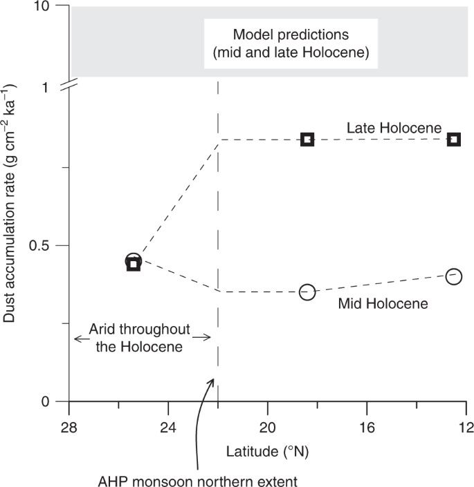
Furthermore, “the northeastern Sahara Desert was arid north of latitude ~ 22°N throughout the length of the Holocene.” While the effect of humidification was gradual and had no exact boundary (latitudinal parallels are themselves arbitrary), this indicates that the greatest effect of the Humid Period occurred between the 22nd and 12th parallel.
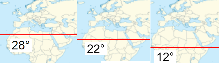
Above 28N, humidification was the least likely. Between 22N and 12N, humidification was the most likely. This roughly corresponds to the modern countries of Sudan, Chad, Niger, Mali, and Western Sahara.

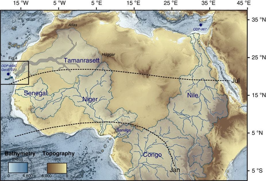
Just like the Wadis of Saudi Arabia, the African Humid Period also had now-extinct rivers, which were covered beneath the shifting dunes. The greatest of these was the Tamanrasett, which was a paleoriver valley similar in length and volume to the modern Indus or Nile.


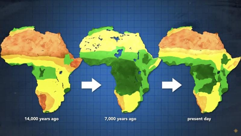
It is true that between 12,000 BC and 3000 BC, Africa was generally much more humid than present day, with a high point occurring between 7000 BC and 6000 BC. However, it should be noted that areas of African rainforest are currently and have been historically agriculturally unproductive. Excessive rainfall, as occurs in the Congo, in the Amazon, and in Indonesia, is not actually optimal for agricultural production.


To clarify, agricultural productivity is here defined not as “sheer growth of all vegetation,” but specifically as “total caloric extraction per acre.” For Americans, the example given is the difference between Iowa and Florida. Florida may receive more rainfall than Iowa, and more sunshine than Iowa, but Iowa still produces more calories per acre than Florida. Floridian crops like oranges and fruits produce less calories per acre than Iowan crops like corn, potatoes, and wheat.
Part of the reason why winter exposure produces caloric density is due to the evolution of winter crops themselves. The calories contained in corn, potatoes, and wheat were originally utilized by the plants themselves to sustain them through harsh winters. We can think of these energy reserves as the plant “charging its battery” to survive through harsh winters, where it goes into hibernation. By contrast, non-winter crops never needed to create these energy reserves. Warm weather fruits are sweet, not because they contain an abundance of calories, but because sugar is more bioavailable than starches. In other words, sugar is more easily digestible by animals than starch. Ants, for example, are more attracted to sugar than they are to bread.
Fruit plants are seeking to attract animals via the production of sugar so that these animals carry and spread the plant’s seeds. Winter crops, by contrast, produce starches which help the plant survive through the cold season. These two evolutionary strategies may not be technically “R” or “K” selective in a scientific sense, but at least in a broad metaphorical sense, we can think of tropical fruits as “R” selective” while winter crops are “K” selective.
Excessive rainfall promotes the growth of R selective plants, such as fruit trees, while moderate or seasonal rainfall promotes the growth of K selective crops, such as grains, corns, and root vegetables. The proximity of early agricultural civilizations to deserts (such the Arabian desert, the Saharan desert, and the Thar desert) indicates that excessive rainfall was not conducive to caloric cultivation.

The excessive rainfall which occurred between the region of Lake Chad6 and the Congo during the African Humid Period was likely a hindrance to agriculture rather than an advantage. However, the Sahara during this period would have been a plains or steppe ecology rather than a desert ecology, similar to Ukraine, southern Russia, Iowa, Nebraska, Kansas, or Illinois. This would have been optimal for early agriculture. Although the argument is too detailed to be explained here, David Wright theorizes that human activity could have contributed to end of this period.7
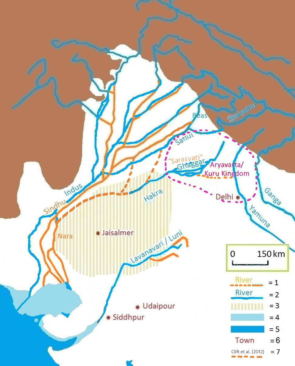
1 = ancient river
2 = today's river
3 = today's Thar desert
4 = ancient shore
5 = today's shore
6 = today's town
7 = dried-up Harappan Hakkra course, and pre-Harappan Sutlej paleochannels
Similarly, in the Indus Valley, it is clear that the Holocene Humid Period not only affected the middle east but also Pakistan. Another possible term which could be used would be Sotadic Humid Period, named after explorer and geographer Richard Francis Burton.

The Sotadic Humid Period is more specific than the Holocene Humid Period because it directly focused on the Sahara, on Arabia, and on Pakistan as three regions which were much more humid than in present day, which had greater rainfall, and contained extensive paleoriver systems and paleolakes which are now extinct or seasonal.
The Indus Humid Period
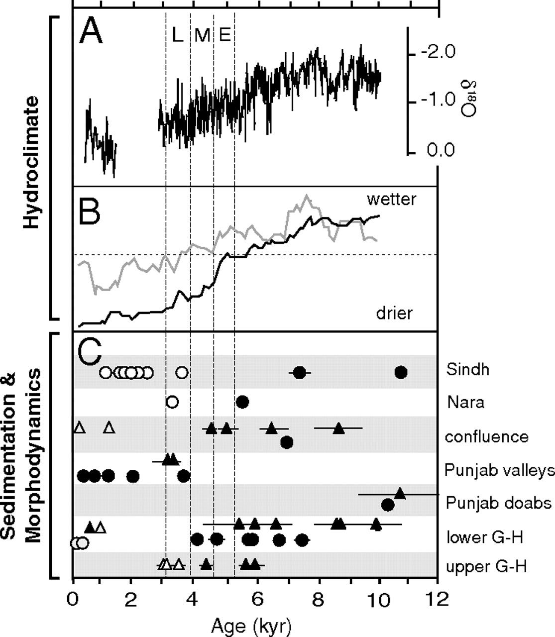
Although India at large is thought of as being very humid and tropical today, the Indus valley does not exist in India, but rather in Pakistan. The Sarasvati river, which is now dry, once ran along the Thar desert,8 which stretches along most of the border of India and Pakistan. This river began to reduce in size beginning in 8kBC to 6kBC, which is in line with desertification in the Sahara and in Arabia. The region experienced punctuated desertification in 3kBC and again in 2kBC. This series of aridification events led to the decline of the Harappan civilization.9 “Recent findings in archaeology [..] put the disintegration of the Indus civilization at c. 1900 B.C.”10 The ease of conquest experienced by invading Indo-Europeans was likely due to this disintegration.
Some caution must be taken in associating all rivers with optimal conditions for human settlement. “A stable abandoned valley, still able to serve as a water source but without the risk of devastating floods, is a viable alternative model for how rivers can nucleate the development of ancient urban settlements.”11 Some models of river decline provide some advantages, including less extreme flooding, as well as the exposure of alluvial soil. Alluvial soil, like Loess soil, is extremely fine and fertile.
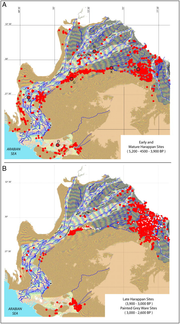

The dramatic decline of the Harappan civilization between 2600 BC and 1700 BC, and the subsequent invasion of Indo-Europeans, seems to mirror and parallel the dramatic decline of the Incan, Mayan, and Aztec civilizations in the millennia prior to the arrival of the conquistadors.
The Neo-Euxine Lake
In 1982, Marine geologist Petko Dimitrov published a study on the Black Sea.12 Fifteen years later, Dimitrov helped publish a paper titled "An abrupt drowning of the Black Sea shelf." The paper stated that "The permanent drowning of a vast terrestrial landscape may possibly have accelerated the dispersal of early neolithic foragers and farmers into the interior of Europe at that time."13
The Neo-Euxine region was optimal for the development of farming. To understand its advantages, we can look at modern day farming production. One of the greatest farming regions in the world is that of the Great Lakes region. This includes Canada, upstate New York, Pennsylvania, Ohio, Indiana, Illinois, Iowa, Wisconsin, and Minnesota. This Great Lakes region is responsible for the majority of North America's agricultural production.
The Great Lakes as a resource provide a source of freshwater. Prior to the automobile, water transportation was crucial for transporting goods, and through a series of canals, the Great Lakes are connected to the Atlantic Ocean. The Great Lakes also provide climatic moderation and create more temperate conditions. This creates milder winters and milder summers. The presence of large bodies of water increases humidity and precipitation due to the evaporation of surface water. Finally, the Great Lakes were originally created by glaciation, which is also responsible for Loess deposits in the American Midwest and plains region.
Conclusion
The Holocene Climatic Optimum, which coincided with the Holocene Humid Period, began after the Last Glacial Maximum ended. Between 14,000 BC and 8000 BC, deserts receded and created large grasslands. Rainfall increased, which sustained paleolakes and paleorivers. The area which was the most affected was the “Paleo-Sotadic zone,” ranging from the Sahel in Africa (from Western Sahara to Sudan), through Arabia, all the way to the Indus Valley in Pakistan. Humidity began to decrease around 6000 BC, and was punctuated by an event known as the “8.2-kiloyear event.” This event dramatically changed the climate, leading directly to Meltwater Pulse 1C, which flooded the Neo-Euxine Lake with seawater.
We can hypothesize that this flooding event led to the migration of refugees north into the steppe, west into Lepenski Vir, east into the Mountains of Ararat (Genesis 8:4), and south into the Hittite region. In other words, the Indo-European expansion was precipitated initially by the Neo-Euxine Lake flood, Meltwater Pulse 1C.14 This initial expansion was then followed by the 4.2-kiloyear event, which precipitated the Indo-European expansion into the Indus Valley.
Both of these are considered "Bond events," named after Gerard Bond. More recent bond events include the Iron Age Cold Epoch of 800 BC (coinciding with the Greek dark ages), the Late Antique Little Ice Age of 600 AD (the period of the British dark ages), and the Little Ice Age of 1500 AD (the period of Mesoamerican and Middle eastern collapse at the expense of European expansion).
https://www.researchgate.net/publication/256173492_Rock_art_landscapes_beside_the_Jubbah_palaeolake_Saudi_Arabia
For convenience and consistency, I convert BP, “before present,” into BC, Before Current era. This is useful because early Egyptian and Sumerian dating is typically provided in BC, not BP. Therefore, speaking of 7k BC to 4k BC is more easily recognizable as a “pre-Egyptian, pre-Sumerian” period rather than as 9k to 6k BP, which is not as easily recognizable. Generally, the decision to use BP is a regular convention when dealing with radiocarbon dating, whereas BC is a historical convention. The distinction between conventions creates the arbitrary and deceptive notion that Egypt and Sumer “came out of nowhere,” a notion I am attempting to disprove.
https://www.researchgate.net/publication/256173492_Rock_art_landscapes_beside_the_Jubbah_palaeolake_Saudi_Arabia
https://whc.unesco.org/en/tentativelists/6636/
https://www.nature.com/articles/ncomms9751
A drop in Sahara dust fluxes records the northern limits of the African Humid Period: https://www.nature.com/articles/s41467-019-11701-z
Reconstruction of Megalake Chad using Shuttle Radar Topographic Mission data: https://www.sciencedirect.com/science/article/pii/S0031018206000241
https://www.frontiersin.org/articles/10.3389/feart.2017.00004/full
https://pubs.geoscienceworld.org/gsa/geology/article-abstract/40/3/211/130795/U-Pb-zircon-dating-evidence-for-a-Pleistocene?redirectedFrom=fulltext
https://www.pnas.org/doi/full/10.1073/pnas.1112743109
http://michaelwitzel.org/wp-content/uploads/2014/06/ejvs0104article.pdf
https://www.nature.com/articles/s41467-017-01643-9
https://www.researchgate.net/publication/312155082_Radiovglerodni_datirovki_na_dnni_utajki_ot_blgarskia_cernomorski_self_Radiocarbon_datings_of_bottom_sediments_from_the_Bulgarian_Black_Sea_shelf
https://www.sciencedirect.com/science/article/pii/S0025322797000078
https://www.researchgate.net/publication/333520190_Initiation_of_human_dispersal_by_rising_water_levels_in_the_Black_Sea_during_the_Holocene?channel=doi&linkId=5cf17408299bf1fb184e721d&showFulltext=true